
Learn how to master backcountry navigation with a GPS. This guide explains key principles, real-life examples, and expert insights for safe and effective wilderness exploration.
- the‑importance‑of‑gps‑in‑backcountry‑navigation
- understanding‑the‑gps‑system‑basics
- navigational‑techniques‑using‑gps
- gps‑limitations‑and‑how‑to‑prepare
- real‑life‑case‑study‑survival‑via‑gps
- planning‑your‑trip‑with‑confidence
1. The Importance of GPS in Backcountry Navigation
Backcountry navigation is one of the most essential survival skills for hikers, backpackers, and explorers venturing into unmarked trails. A reliable GPS device can be a game-changer when topographic maps and compasses aren’t enough. For adventurers exploring Canada’s Pine Cliff wilderness or America’s rugged Pacific trails, knowing how to interpret and act on GPS data can mean the difference between a smooth return and a lost trek.
While traditional tools still hold value, GPS has revolutionized outdoor travel. In 2025, enhanced satellite reception and integrated maps make handheld GPS units more accurate and user-friendly than ever before.
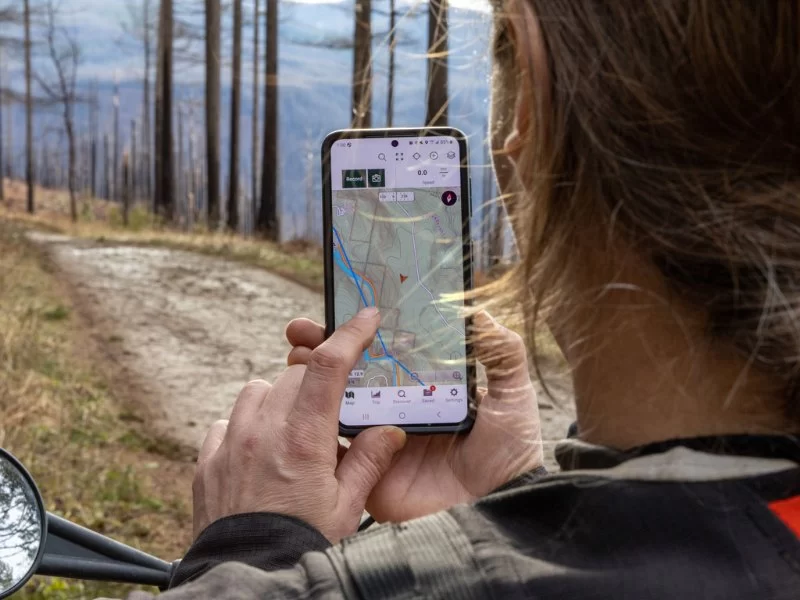
2. Understanding the GPS System Basics
The Global Positioning System (GPS) operates using a constellation of 24 satellites orbiting Earth. Your GPS device triangulates your position by receiving signals from at least three of them. This process calculates your latitude, longitude, and sometimes elevation.
For hikers and campers, this means you can pinpoint your location on a digital map—even without cell service. Devices like the Garmin GPSMAP series or smartphone apps like Gaia GPS are popular among experienced backpackers. Just remember to download offline maps before venturing off-grid.
3. Navigational Techniques Using GPS
Mastering GPS for backcountry navigation involves more than knowing where you are. Here are several practical techniques:
3.1 Marking Waypoints: Drop pins at key trailheads, campsites, water sources, or forks in the path. This helps you retrace your route if visibility drops or paths get confusing.
3.2 Route Planning: Pre-load your entire hiking trail into your device using GPX files. This feature allows you to follow a breadcrumb trail and avoid veering off course.
3.3 Distance and Elevation Awareness: Use GPS to monitor real-time distance traveled and elevation gain, helping conserve energy and set realistic hiking goals.
With consistent practice, these skills become second nature, much like learning to read a compass or terrain map.
4. GPS Limitations and How to Prepare
Despite its strengths, GPS navigation isn’t foolproof. Devices can run out of battery, lose signal under dense tree canopy or steep canyons, and even malfunction in harsh weather. That’s why the golden rule of backcountry safety still applies: “Don’t rely on a single tool.”
Always bring a backup battery or solar charger, a physical map, and a basic compass. Learn to triangulate landmarks and stay aware of your surroundings. GPS should enhance your awareness—not replace it.
5. Real-Life Case Study: Survival via GPS
In 2024, a group of novice hikers set out into Ontario’s remote backcountry, near Pine Cliff Resort. Midway through their three-day hike, a heavy storm rolled in, flooding trail markers and confusing paths. With visibility reduced, they activated their GPS devices to locate a previously marked safe campsite.
Thanks to waypoints they had logged earlier and a downloaded offline map, they made it back safely, where park rangers later praised their preparedness. This story highlights how proper GPS use can turn a near-disaster into a safe outcome.
6. Planning Your Trip with Confidence
Using GPS for backcountry travel shouldn’t feel intimidating. Practice locally, such as within regional parks or near the Pine Cliff Resort trails, and gradually take on more remote terrain. Combine your GPS knowledge with common sense and basic orienteering.
At Pine Cliff Resort, we recommend guests bring GPS devices on extended hikes and offer guides on how to use them properly. Whether you're hiking solo or exploring with friends, confidence grows when you pair technology with preparation.
Haskins Valley Family Campground
16731 Bucks Lake Rd, Quincy, CA 95971, USA
Visit Location PageSusquehanna Shores Campground
121 Susquehanna Beach Rd, Falls, PA 18615, USA
Visit Location Page