🌲 Introduction / Overview: True Northwoods Primitive Camping
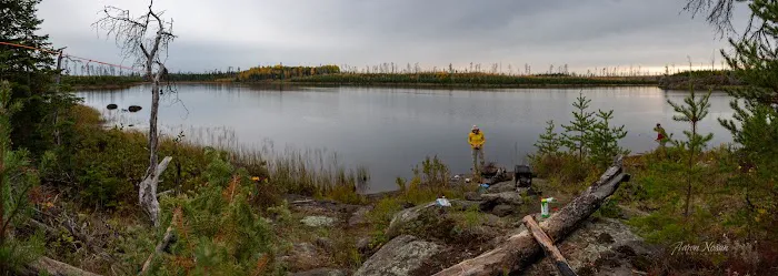
The Lake Diana Campsite is an informal, highly remote area located on the famously rugged Powwow Trail within the Boundary Waters Canoe Area Wilderness (BWCAW), near Ely, Minnesota. Unlike traditional developed campgrounds, Lake Diana is not listed as one of the few currently designated and maintained campsites along the Powwow Trail loop. Instead, it refers to a scenic vicinity—specifically, a notable "green zone" near the Diana Creek crossing—where dispersed camping is possible under specific BWCAW regulations, or it may refer to a primitive, unmaintained site from before the 2011 Pagami Creek Fire.
This is a destination for the dedicated, wilderness-savvy Minnesota backpacker. It demands self-sufficiency, expert navigation skills, and a complete adherence to Leave No Trace principles. The customer review stating, "Not for the family," serves as a stark but honest warning: this area of the Powwow Trail is physically challenging, technically complex, and far removed from any emergency assistance or modern comforts, making it unsuitable for casual campers or young children.
---
📍 Location and Accessibility: A Hike Deep into the BWCAW
The Lake Diana vicinity is situated along the main loop of the approximately 30-mile Powwow Trail in the Superior National Forest. It is a multi-mile hike from the trailhead, requiring significant time and effort to reach.
- Address Proximity: Ely, MN 55731, USA is the nearest town where permits are obtained and supplies are secured, but the site itself is deep in the wilderness.
- Trailhead Access: Access begins at the Isabella Lake Entry Point (BWCAW Entry Point #86). Getting to the trailhead involves driving State Highway 1 east of Ely and then navigating several miles of unpaved, potentially rough Forest Roads (such as FR 377).
- The Hike: From the trailhead, the journey is arduous. You first traverse "The Stick" portion (approximately 2.7 miles) to reach "The Wye" where the loop begins. The Lake Diana area is then located on the loop portion, requiring a substantial hike—roughly 3.9 miles clockwise from The Wye to the Diana Creek Bridge.
- Navigation Warning: The Powwow Trail is notorious for being difficult, often obscured by new growth and blowdown from the 2011 fire. Visitors must rely on detailed maps, a compass, and often GPS with pre-downloaded tracks, as the official trail may not be clearly visible.
- Water Crossings: Expect challenging wetland and beaver dam crossings where the trail may be flooded or completely submerged, necessitating waterproof or quick-drying footwear.
---
🛠️ Services Offered
As a primitive, dispersed camping area, visitors should expect no conventional services and must be fully prepared to handle all logistics themselves.
- Designated Facilities: Based on current trail guides, the Diana Lake vicinity does not feature a standard, maintained fire grate or latrine. Any camping in this area must adhere to dispersed camping rules if it is not one of the few designated sites.
- Tent Area: The area is known to have a "green zone" near the Diana Creek bridge where multiple tents can be pitched in a spacious clearing.
- Water Source: The Diana Creek crossing and Lake Diana itself offer a source of non-potable water. Water purification is absolutely mandatory using filters, chemical treatment, or boiling.
- Waste Management: Campers must practice strict Leave No Trace ethics. All trash must be carried out. Human waste must be buried 6 to 8 inches deep and at least 200 feet from water, camp, and trails, or deposited in a wilderness latrine if a primitive one exists nearby.
- Food Storage: Wildlife, particularly bears, is common. Bear-resistant food storage is required by the USFS, which means using approved canisters or finding suitable trees to hang food well away from your camp.
- Emergency Services: There is virtually no cell phone reception. Communication and self-rescue equipment (like a satellite messenger) are critical.
---
✨ Features / Highlights
The draw of the Lake Diana area is its pristine wilderness setting and unique ecological characteristics.
- The "Green Zone" Oasis: The Diana Lake vicinity is one of the few "green zones" on the Powwow Trail—areas that largely escaped the worst of the Pagami Creek Fire. This offers a welcome contrast of older, established pines and shade compared to the surrounding regenerating burn zone.
- Tamarack Log Bridge: The crossing over Diana Creek features a newly laid tamarack log bridge (as of late 2020), a point of pride for the volunteer efforts that maintain this challenging trail, and a vital crossing point.
- Wildlife Viewing: The remoteness and varied habitat (burn zone meeting green zone) create excellent opportunities for viewing Minnesota's wildlife, including moose, wolves, and a wide array of birds.
- Challenging Solitude: The difficulty of the trail ensures that anyone who reaches Lake Diana has earned their solitude. This is an unparalleled opportunity for a peaceful, reflective backcountry experience, far from crowded trails.
- Ecological Contrast: The area provides a stunning perspective on the chaotic beauty of forest fire recovery, standing as a living monument to nature's resilience.
---
📞 Contact Information
The Lake Diana Campsite is a wilderness location without an on-site office. For all trip planning, permits, and current trail condition reports, use the following contact information:
Address (General Area):
Ely, MN 55731, USA (Remote Wilderness Location)
Primary Ranger District Contact (Kawishiwi Ranger District):
Phone:
(218) 365-7600 (Superior National Forest - Kawishiwi Ranger District)
---
✅ What is Worth Choosing: The Reward of the Uncompromised Wild
For Minnesota outdoor enthusiasts, choosing the Lake Diana area on the Powwow Trail is a declaration that you seek the uncompromised wild. It is worth choosing for the profound sense of accomplishment that comes with successfully navigating one of the region's most challenging backcountry routes. The isolation, the lack of human infrastructure, and the raw, post-fire landscape combine to offer a truly humbling and memorable experience. You are choosing a trip where the difficulty is part of the draw, where the lack of development guarantees solitude, and where your skills as a backpacker will be fully tested and ultimately, rewarded.
If you are an experienced, prepared backpacker with strong navigational skills, Lake Diana offers a magnificent goal on a multi-day wilderness loop—an authentic slice of the BWCAW reserved only for those willing to earn it.